Tuesday, November 30, 2010

Glaciers and what will happen if they melt


Glaciers are melting faster today as compared to the past many centuries. Why this sudden change? Almost everyone believe that the prime reason for this is sudden and rapid industrialization which in turn has caused global warming - the prime culprit of fast melting glaciers.
Global warming is the rise in average global temperature that has happened over the past century. The 'industrial revolution' is the main cause of this rise in average temperature. The indiscriminate burning of fossil fuels has resulted in extreme atmospheric pollution leading to this condition. Coal is still burnt in huge quantities for various reasons such as electricity production. Burning of oil is a major culprit in the past century. Deforestation has increased to procure wood and make more space available for farming, resulting in an increase in carbon dioxide concentrations. All these pollutants help in trapping more heat in the earth's atmosphere, increasing global temperatures.        
                                                                                                                                                                                        
It is due to this increase in temperature that glaciers are melting more than they actually should. When a glacier melts fully, it exposes the earth below. Glaciers absorb approximately 20% heat from the sun, reflecting back 80%. When the earth gets exposed this percentage gets reversed. This in turn causes a further increase in temperature. This is a vicious trap which has already begun and it will be almost impossible for us to stop it totally.


In the future the global temperature will in all likelihood keep increasing, melting glaciers even faster than they are today.
Faster than normal melting glaciers will cause the streams and rivers to overflow causing flooding. This is a reality that many places have and are currently facing. Those living in close proximity to these rivers will need to relocate. Farmlands get destroyed in these flood waters. Higher up on mountains this excess water creates new ponds. As these ponds keep getting filled with more water they form lakes with the pressure on the boundaries increasing. There is always a threat of these lakes bursting, causing huge floods in villages situated below.


 Once the glacier has totally melted, the streams and rivers will run dry. Farmland will turn dry. Those depending on freshwater from the melting glacier will have to relocate.

Places that depend on the constant flow of this water for the production of electricity will have to look for other sources to produce electricity. This will cause further atmospheric pollution and cost much more to produce.

 Sea levels that have already risen due to warmer waters will rise even further when all this water from melting glaciers empty into the sea. At immediate risk will be to those living in low-lying areas in close vicinity to seashores. These areas will get flooded and sweet groundwater will get polluted with sea water making it unfit for human use. All these people will have to relocate.


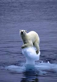
Many animals, birds, and fish that depend on the fresh water from glaciers that empty directly into the sea will become endangered. Corals will suffer because of low sunlight due to increasing sea-levels. Fish feeding on these corals will in turn get affected. Animals and birds feeding on these fish will be affected.

There are many more dangers that could crop up due to fast melting glaciers in the coming years if we do not do something to reduce the menace of global warming immediately. Each one of us can play a part in helping reduce harmful emissions, leading to a possible reduction in future global warming.


Monday, November 22, 2010

Cinder Cone & Shield Volcanoes


Alaska Cinder Cone


Cinder Cone
In a cinder cone, lava erupts from a small vent in the crust and 'sprays' melted rock fragments into the air where they then fall back to earth in a pile. These rock fragments are glassy, gas-filled chunks of lava called cinders or scoria that cool rapidly as they sail through the air and land next to the vent opening, slowly accumulating in the geometric shape of a cone. Some of the most dramatic volcanic eruptions are these displays of lava fountains shooting sparkling, glowing glass-like rock fragments into the air from cinder cones. 


Hawaiian Shield Volcano

Shield volcanoes are the more quiescent, lumbering giants of the volcano world. Although these types of volcanoes are not small by any means, the eruptions they produce can be pretty "ho hum" compared to the enormous explosive potential of the Extreme Volcanoes. The biggest single mountain in the world is a shield volcano that was slowly built up from the floor of the Pacific Ocean over hundreds of thousands of years.


This massive mountain rises just over 13,000 feet from the surface of the Pacific Ocean, but from its true base on the sea bed Mauna Loa towers over 33,000 feet tall. Mauna Loa is one of five massive shield volcanoes that make up the Big Island of Hawaii. This towering giant had some pretty humble beginnings.

The Cinder Cone Volcano is the classic, cone-shaped peaks we commonly associate with a lava-spewing eruption. Eruptions from cinder cones are pretty small potatoes, as far as volcanic eruptions go. They tend to be small, hill-sized volcanoes that range in height from tens to hundreds of meters high and they can build up over short periods of a few months to a few years. Cinder cones are characterized by their steeply angled sides and conical shapes. In fact, these mini-volcanoes are most often found on the flanks of larger, mountain-sized volcanic peaks.

A shield volcano like Mauna Loa owes its shape to the way the lava erupts from a vent in the earths crust that begins as a fissure, or crack. Pockets of superheated magma well up from beneath the crust, causing it to bulge upward. As the sea floor bulges from the movement of the magma, cracks form in the crust, sort of like the way the top of a cake cracks as it bakes in the oven. These fissures in the crust become weak areas of thin crust that give way to the upward force of the magma, eventually allowing it to break through. The overlying weight and pressure of the ocean water affects the way the magma emerges from fissures in the sea floor. The runny lava oozes out of the fissures and spreads out around the crack, cooling as it contacts the seawater. This slow and gradual accumulation of thin layers of lava builds up over long periods of time, forming a long, shield-shaped volcano.

A shield volcano like Mauna Loa owes its shape to the way the lava erupts from a vent in the earths crust that begins as a fissure, or crack. Pockets of superheated magma well up from beneath the crust, causing it to bulge upward. As the sea floor bulges from the movement of the magma, cracks form in the crust, sort of like the way the top of a cake cracks as it bakes in the oven. These fissures in the crust become weak areas of thin crust that give way to the upward force of the magma, eventually allowing it to break through. The overlying weight and pressure of the ocean water affects the way the magma emerges from fissures in the sea floor. The runny lava oozes out of the fissures and spreads out around the crack, cooling as it contacts the seawater. This slow and gradual accumulation of thin layers of lava builds up over long periods of time, forming a long, shield-shaped volcano.


Shield volcanoes are not the only type of volcano that forms on the ocean floor, nor are all shield volcanoes formed only in the sea. As shield volcanoes like the Hawaiian Islands build up from the sea floor they are known as sea mounts - undersea mountains. But once they reach the surface of the sea they become islands. As the eruptions of fluid lava continue unimpeded by the weight of overlying seawater, the runny nature of the liquid lava continues to build wide mountains with long, gentle slopes. Basalt lava tends to build enormous, low-angle cones because it flows across the ground easily and can form lava tubes that enable lava to flow tens of kilometers from an erupting vent with very little cooling.

Thursday, November 18, 2010

Composite Volcanoes


     Composite volcanoes also known as stratovolcanoes make up some of the most know volcanoes that we have here on earth. A composite volcano is made up of many layers of harden lava and volcano ash of eruptions that have already taken place. That is usually why they can make such peaks that they have because of the constant overlapping that occurs. They really make beautiful mountains and draw people close to them and that usually isn’t good because when these volcanoes blow they are usually violent and have a higher number of casualties than other volcanoes.
            Like said before composite volcanoes are made of an overlapping of lava that comes out when there is an explosion. All the lava that comes out during like miner explosions usually doesn’t get to far so what is left just keeps getting piled and piled on top of each other. While the lava keeps piling up this is what causes for the high steep tops of these volcanoes. Also during these eruptions cinder bombs and blocks are thrown out and so when the next eruption occurs the lava flows cement these all together also adding height to the volcano.

These volcanoes mostly always have a violent eruption. The eruption is caused by the viscous magma, when it rises to the top it usually clogs up the crater pipe and gases in the crater pipe get lock up. So the pressure will increase and the magnitude of the eruption. During these eruptions the volcanoes will throw out debris, have lots of lava flow they can also causes landslide, avalanches and even tsunamis. The eruptions of these volcanoes cause the most damage than any of the rest. Some of the most well know volcano eruptions are from composite volcanoes like Mt. St Helens, Mt.Fuji and Mt. Etna.


Friday, November 12, 2010

Snow and Snowstorms

Snow is always seen during the winter. Kids like to make snowman and I myself haven’t gotten to experience snow.  In the United States snow is seen up in the north.  Even northern Arizona sees snow. Snow is frozen water that falls from the sky. All snow flakes have six sides, but no two snow flakes are the same. Snow is precipitation in the form of small white ice crystals. Snow is formed from the water vapor in the air at a temperature of less than 32 degrees Fahrenheit.
As snow looks harmless there are other things that are caused by snow and wind together. A snowstorm is when snow falls from the sky as precipitation. A blizzard is the worst kind of snowstorm, in which strong winds blow snow into snowdrifts (huge piles) that can bury people and possessions. Its official definition is a tempestuous, frigid snow storm with blustery, piercing winds of 35 miles per hour or more and a wind-chill factor as low as -20º Fahrenheit. Transportation is difficult and dangerous during blizzards because air temperatures can be 10ºF or lower, with visibility less than 400-500 feet. When there is no much snow that people and animals cannot tell the earth from the sky, it is known as a whiteout. In this disoriented state, humans and livestock can lose their way and freeze to death. Blizzards carry the risk of hypothermia, frost bite, suffocation, and being stranded. Sub-zero temperatures, arctic conditions, and 100 mph winds in mountainous regions pose additional threats. Snowstorms happen when a mass of very cold air moves away from the Polar Regions. When it collides with a warm air mass, the warm air rises quickly and the cold air cuts underneath it. This causes a huge cloud bank to form, leading to heavy snowfall. Snow will only fall from the cloud if the temperature of the air between the bottom of the cloud and the ground is below 40ºF. A higher temperature will cause the snowflakes to melt as they fall through the air, turning them into rain or sleet. Snowflakes form when ice crystals collide in a cloud and stick together. Every snowflake has six sides, and no two snowflakes that fall are exactly alike. Their varying shapes are a result of the different weather conditions in which they are produced. Needle and rod shapes are formed by cold air, while warmer air results to more complicated patterns.


Saturday, November 6, 2010

Hail


Corn Crop after hail storm
On November third two thousand and ten, there were reports of hail damage in the states of Texas, Louisiana, and Arkansas.  Hail has caused one billion dollars of damage for property and crops each year in the United States.  At times a piece of hail can be as big as a baseball. On April 10, 2001 Kansas City had a hail storm, which cost United States $2 billion for the damage. A small hail storm can damage the plants even though people may think it is not important. U.S. hail is most common in the area where Colorado, Nebraska, and Wyoming meet, known as "Hail Alley." Parts of this region average between seven and nine hail days a year.


Hail is formed in huge cumulonimbus clouds, commonly known as thunderheads. The development of hail starts inside a thunderstorm. Where there are strong updrafts of warm air and downdrafts of cold air. If water droplets are present the can be carried to the freezing level with temperatures that reach below 32F and the droplets will freeze. The frozen droplets are carried by the cold downdrafts and as it travels downward it may melt into warmer air toward the bottom of the thunderstorm. A repetition of the frozen droplet being carried up by an updraft and taken to the freezing level will add another layer of ice which creates HAIL. With the several layers the ice, the hail fall to the ground.


The size of hail is not so different from a raindrop. Mostly hail is 2inches in diameter or less. The largest hailstone fell on June 23, 2003 in Aurora, Nebraska and had a diameter of  7.0 inches, a circumference of 18.75 inches, and weighed just under 1 lb. The heaviest hailstone fell in Coffeeville, Kansas on September3, 1970 and weighed 1.67 lbs.  It had a diameter of 5.7 inches and a circumference of 17.5 inches.

Friday, October 29, 2010

Tsunami

There are several events that have happened that have an affect on the place that was hit and for people that live in the west coast to be aware that one day it can happen to them. The tsunami of 2004 in India, I remember that all my family would tell me that if a tsunami hits I will be first to be taken. My aunt´s family lives in Santa Ana California while I lived on the west coast of Newport Beach. I came to believe that I wave would actually take my house and I would be floating by my cousin´s house. As a child I had a big imagination.
The phenomenon "tsunami" is a series of traveling ocean waves of extremely long length generated by disturbances associated primarily with earthquakes occurring below or near the ocean floor. Underwater volcanic eruptions and landslides can also generate tsunamis. In the deep ocean, their length from wave crest to wave crest may be a hundred miles or more but with a wave height of only a few feet or less. They cannot be felt aboard ships nor can they be seen from the air in the open ocean. In deep water, the waves may reach speeds exceeding 500 miles per hour.
Tsunamis are a threat to life and property to anyone living near the ocean. For example, in 1992 and 1993 over 2,000 people were killed by tsunamis occurring in Nicaragua, Indonesia and Japan. Property damage was nearly one billion dollars. The 1960 Chile Earthquake generated a Pacific-wide tsunami that caused widespread death and destruction in Chile, Hawaii, Japan and other areas in the Pacific. Large tsunamis have been known to rise over 100 feet, while tsunamis 10 to 20 feet high can be very destructive and cause many deaths and injuries.
The Tsunami Warning System in the Pacific, comprised of 26 participating international Member States, monitors seismological and tidal stations throughout the Pacific Basin. The System evaluates potentially tsunamigenic earthquakes and disseminates tsunami warning information. The Pacific Tsunami Warning Center (PTW) is the operational center of the Pacific TWS. Located in Honolulu, Hawaii, PTWC provides tsunami warning information to national authorities in the Pacific Basin.

Friday, October 22, 2010

CYCLONES


Hurricanes, cyclones and typhoons are tropical cyclones with maximum sustained wind speed exceeding 119 km/h near their centres, and every year responsible of thousands of victims.
"Hurricane", "cyclone" and "typhoon" are different terms for the same weather phenomenon which is accompanied by torrential rain and maximum sustained wind speeds exceeding 119 kilometers per hour. In the western North Atlantic, central and eastern North Pacific, Caribbean Sea and Gulf of Mexico, such a weather phenomenon is called "hurricane". In the western North Pacific, it is called "typhoons". In the Bay of Bengal and Arabian Sea, it is called “cyclone". In western South Pacific and southeast India Ocean, it is called “severe tropical cyclone.” In the southwest India Ocean, it is called “tropical cyclone.”
Between 1886 and 1998, out of the 566 Atlantic hurricanes in the Atlantic, twenty two have grown as strong as to become Category 5 hurricanes with maximum sustained wind speeds exceeding 249 km/h. The worst recent tropical cyclones include Hurricane Mitch (Honduras) in 1998, Hurricane Katrina (USA) in 2005 and most recently hurricane Gustav (Haiti) in 2008, and severe cyclone Nargis (Myanmar) in 2008.
The 2008 Atlantic hurricane season was devastating, with casualties and widespread destruction in the Caribbean, Central America and the United States of America. For the first time on record, six consecutive tropical cyclones made landfall on the United States of America, and two major hurricanes (Gustav and Ike) hit Cuba.
In the East Pacific, sixteen named tropical cyclones were recorded in 2008, of which seven evolved into hurricanes and two of them into major hurricanes at Category 3 or higher. In the Western North Pacific, twenty two named tropical cyclones were recorded in 2008, ten of which were classified as typhoons compared to the long-term average of twenty seven and fourteen, respectively.
The Western North Pacific has been hit several times in September - October 2009 by numerous typhoons such as Ondoy, Ketsana, Parma, Lupit and Mirinae, causing many casualties.

Friday, October 15, 2010

El Niño vs. La Niña

When I was in second grade, which it were the years of nineteen-ninety seven and nineteen-ninety eight, I experience El Niño. For two months in Newport Beach, California there was rain. There was a heavy rainfall of about twelve inches. As my school was by the beach most sea level rooms were flooded. During El Niño all we did was stay inside & played board games. There were periods when the rain would stop and then in the night the rain would start again.
 El Niño is a change in the wind direction. Air pressure differences in India the pressure is lower and high at the date line. El Niño is known as the Southern oscillation. During the El Niño, the trade winds weaken. The sea surface temperature raises well above long term averages over the central eastern tropical pacific. These areas will have heavy rain shifting from the western into the central tropical pacific. El Niño is the warm phase of the tropical atmosphere/ocean interaction. El Niño influences the prevailing circulation of the atmosphere in middle latitudes mostly in the winter. There are significant pacific surfaces temperature changes as well as atmosphere. Ocean circulations patterns change and collapse important Southern American fisheries. El Niño begins when the air pressure gradient of the tropical pacific starts to weaken. The air pressure falls over the eastern tropical pacific and rises over the western pacific. The warm surface of water will slowly drift eastward over the tropical pacific. Anomalies for El Niño are normally between two to three Celsius degrees below the long term average. As El Niño affects the Pacific Ocean, the Atlantic Ocean is experiencing La Niña.
            In contrast, La Niña is the cold phase of the tropical atmosphere/ocean interaction. The air pressure differences high in India and low in the date line. La Niña the northern oscillation. In addition, the trade winds during La Niña are extremely strong across the tropical pacific with low sea surface temperatures, which are lower than usual, and the central and eastern tropical pacific. In the eastern tropical pacific, there are strong trade winds and upwelling.

Sunday, October 10, 2010

Rain


Precipitation has many forms. The one form I have experience is rain. Rain develops when growing cloud droplets become too heavy to remain in the cloud and as a result, fall toward the surface as rain. Rain can also begin as ice crystals that collect each other to form large snowflakes. As the falling snow passes through the freezing level into warmer air, the flakes melt and collapse into rain drops. Before it can rain, there must moisture or humidity in the air. In order for there to be moisture in the air, water must evaporate. The air is most moist by the oceans and to a lesser extent large lakes like the Great Lakes. Air flows over these large bodies of water picking up moisture as it evaporates off the surface. The air then flows over the land and to us it feels like a form of humidity. If air rises, such as up a mountain slope, or when encountering a cold front or warm front, the air cools and the moisture condenses into clouds and rain. As a result, areas near oceans and lakes, and areas where the air flows off an ocean and up a mountain, are likely to get a lot of rain. Where weather fronts are seen those areas will have a lot of rain. Other areas that are near mountains will not see rain as much an example is our home state Arizona. The downsides of the mountain meteorologist call this a "rain shadow." This occurs because most of the moisture falls out as rain as the air rises up the one side of the mountain. Then, the air dries as it descends down the other side. This is another reason why Arizona and much of the Rocky Mountain region is much drier than other places in the country.

Saturday, September 25, 2010

Tornadoes

Tornadoes occur in many parts of the world. Tornadoes are destructive forces of nature and are found frequently in the United States east of the Rocky Mountains during the spring and summer months. In an average year, 800 tornadoes are reported nationwide, resulting in 80 deaths and over 1,500 injuries. Tornado is defined as a violently rotating column of air extending from a thunderstorm to the ground. The most violent tornadoes are capable of tremendous destruction with wind speeds of 250 mph or more. Damage paths can be in excess of one mile wide and 50 miles long. Thunderstorms develop in warm, moist air in advance of eastward-moving cold fronts. These thunderstorms often produce large hail, strong winds, and tornadoes. Tornadoes in the winter and early spring are often associated with strong, frontal systems that form in the Central States and move east. Occasionally, large outbreaks of tornadoes occur with this type of weather pattern. Several states may be affected by numerous severe thunderstorms and tornadoes. During the spring in the Central Plains, thunderstorms frequently develop along a "dry line," which separates very warm, moist air to the east from hot, dry air to the west. Tornado-producing thunderstorms may form as the dry line moves east during the afternoon hours. Along the front range of the Rocky Mountains, in the Texas panhandle, and in the southern High Plains, thunderstorms frequently form as air near the ground flows "upslope" toward higher terrain. If other favorable conditions exist, these thunderstorms can produce tornadoes. Tornadoes occasionally accompany tropical storms and hurricanes that move over land. Tornadoes are most common to the right and ahead of the path of the storm center as it comes onshore.


When tornadoes are develop first there is a wind direction with an increase in wind speed. Which the tornado increases in height and horizontal spinning effect in the lower atmosphere. The air rises within the thunderstorm updraft tilts the rotating air from horizontal to vertical. The area rotation is mostly two-six miles wide and extends to a storm.

Friday, September 17, 2010

EL NINO


Have you ever experience rain for about a week none stop? Well in the year of nineteen ninety seven El Niño hit on the pacific coast. El Nino is a change in wind direction and with that change there is rain. El Niño is very different from La Niña, which hits over in the East Asia. Well my experience I was in first grade and El Niño hit in the winter.  Being the Best on the Beach Elementary it was not that year. The classes that were at sea level reached about a foot of depth. Those classes were for the sixth graders and fifth graders. That whole week or two they had wet classrooms. Through out the school the carpet only got soaked. Other than the school, the city of Newport Beach the water reached the sidewalks. My mother at that time had a Honda Civic so it felt like we were driving in the ocean. Being that El Niño is rain, that season it happened it would be raining a whole day and then stop for awhile. As several people dislike the rain, El Niño has been a favorite memory for me. School during El Niño was not that much fun because recess was spent playing board games and I did that at home.

El Niño is distinguished by unusually warm ocean temperatures in the Equatorial Pacific. El Niño is an oscillation of the ocean-atmosphere system in the tropical Pacific having important consequences for weather around the globe. Some consequences are increased rainfalls across the south of the US. Trade winds blow towards the west across the tropical Pacific. These winds pile up warm surface water in the west Pacific. The temperature of the sea is about 8 degrees C higher in the west, with cool temperatures off South America. Rainfall is found in rising air over the warmest water, and the east Pacific is relatively dry. During El Niño, the trade winds relax in the central and western Pacific leading to a depression of the thermo cline in the eastern Pacific, and an elevation of the thermo cline in the west. The eastward displacement of the atmospheric heat source overlaying the warmest water results in large changes in the global atmospheric circulation, which in turn force changes in weather in regions far removed from the tropical Pacific.

Tuesday, September 7, 2010

Earthquakes

Earthquakes are caused when rock underground breaks along a fault. This energy causes the seismic waves that make the ground shake. When one rubs things together they tend to stick, so when two blocks of rock or two plates are rubbing against each other, they will stick a little. The sliding process is not smooth; the rocks catch on each other. The rocks are still pushing against each other, but not moving. The rocks break because of all the pressure. With the pressure comes the earthquake. During the earthquake all that the blocks of rocks or plates are doing is find a place where they can be stuck to each other again. The spot underground where the rock breaks is called the focus of the earthquake. The place right above the focus (on top of the ground) is called the epicenter of the earthquake. Earthquake-like seismic waves can also be caused by explosions underground. These explosions, however, don't cause very strong seismic waves. Sometimes seismic waves occur when the roof or walls of a mine collapse.
Funny thing about earthquakes for me back in Newport Beach, California there were not many earthquakes as one feels here in Arizona. I recall having the neighbors’ house being remodel and the street felt like an earthquake. Being on the second floor the movement of the ground was stronger. So what is the first thing one should do? Go under a table or bed in my case. It was so much fun just knowing that I knew what to do in this type of issues of the environment. In the three years here in Somerton I have been in two earthquakes this year. The first one, I was at work with my mother and the fans and frames in the reception area moved. Outside the cars that were parked moved about half a foot. As everybody knows an earthquakes consist of aftershocks. Well after that the mini after shocks were felt able.   On Easter Sunday, an earthquake well known that the most disaster was done in Mexicali was something different I have felt in my nineteen years of life. At around four o’clock the ground started to shake. The trees would lean back and forth. At the time of the earth quake I was at a picnic with my church and we were jumping rope. To be honest I thought it was all the weight of my friends jumping the rope that was moving the ground.  So being outside the earthquake is not so bad.

Thursday, September 2, 2010

Lightning

Have you ever seen light fall from the sky?
Well when there are thunderstorms keep your eye out for that light I am speaking of.

<>
Cloud To Air
    When a thunderstorm has lightning, every minute that goes by it is beauty that nature brings to the earth. Some people are afraid of lightning, which one should be because one strike of lightning can kill a person. My experiences of lightning have been in the three years that I lived here in Somerton and when I traveled from California to San Luis Rio Colorado, Sonora. One winter on my way to San Luis I drove in a thunderstorm through the desert before arriving to Yuma. The clouds of course were pitch black and lightning fell from left to right of the road. There were sequences of several lightning bolts in a row. If I remember correctly the lightning color was red and purple. The closer I drove the more excited I got. Recently, on August 26, 2010 a thunderstorm came through the city of Somerton. The thunderstorm started off by strong winds. After an hour of just winds there was drizzle of rain and then it showered for about fifteen minutes. Rain does not like to pour over Somerton that long. Along with the drizzle lightning bolts started to fall. The color of the lightning was blue and it lighted up the town. I can not wait for more thunderstorms.


Lightning Between CLouds
    Lightning comes from thunderstorms and are arranged when liquid and ice particles above the freezing level collide. This then builds a large electrical field in the clouds. Lightning can occur in three different places: between clouds only, between the cloud and air, and between the cloud and the ground. The temperature of Lightning can reach fifty thousand degrees Fahrenheit, which is hotter than the surface of the sun. The heat that is produced from lightning can catch an object on fire.


Thursday, August 26, 2010

Global Warming

Weather events that are happening today are due to global warming. Russia is having fires across the country. Monsoon season in Asia is predicted to have heavier rain and more hurricanes. Landslides from China and an iceberg of Greenland ice sheet are falling apart. As these weather events have been seen before, however may global warming causing the events to be worse? The increase of heat is being caused from greenhouse gases. As the world heats up the rainstorms of the summer will be heavier and in the winter the snowstorms will be bigger. 
The areas where it should be cold are warming up. The North Pole is already being affected. The arctic animals are having less territory to live on. The ice is melting and the oceans temperatures are colder and this results that in the Pacific Ocean it creates weather events like El Niño and La Niña. The animals in the arctic are the major group of animals that have been affected the most by global warming. One thinks how the greenhouse can affect up north when we are miles away.
            In my case I will be included with those people that do not worry about the well being of the environment and species. After reading several articles on global warming I realized that it is getting worse. The last time I heard a lecture of global warming was in high school. I did not think much of it until now. All over the world, the climate has been changing and no one has an exact solution to prevent all of the weather events. All I hear is that the greenhouse effect is causing the atmosphere to warm up.
The example of the images may seem funny and yes it does bring a giggle when you see it. Even after one has seen the images, one starts to rethink what is going on with the world’s atmosphere. Scientists say that the greenhouse gases must be controlled; nevertheless there is no action upon this.
http://environment.about.com/od/globalwarming/a/global_warm_wil.htm